Podlaska Biblioteka Cyfrowa udostępnia 107 240 obiektów cyfrowych
Obiekt
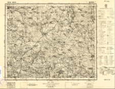
Tytuł: Mapa topograficzna Polski: Brańsk Pas 38 Słup 36 (pow. Bielsk-Podlaski, woj. białostockie).
Format:
Opis:
sygn. K-1319 ; 1 mapa: czarno-biała; 46x36 cm ; skala 1:100 000
Język:
Prawa:
Domena publiczna (Public domain)
Digitalizacja:
Biblioteka Uniwersytecka im. Jerzego Giedroycia w Białymstoku
Identyfikator zasobu:
Wydawca:
Wojskowy Instytut Geograficzny
Miejsce wydania:
Lokalizacja oryginału:
Biblioteka Uniwersytecka im. Jerzego Giedroycia w Białymstoku
Kolekcje, do których przypisany jest obiekt:
Data ostatniej modyfikacji:
5 maj 2023
Data dodania obiektu:
27 paź 2006
Liczba wyświetleń treści obiektu:
1 200
Liczba wyświetleń treści obiektu w formacie PDF
1242
Wszystkie dostępne wersje tego obiektu:
https://pbc.biaman.pl/publication/117
Wyświetl opis w formacie RDF:
Wyświetl opis w formacie OAI-PMH:
| Nazwa wydania | Data |
|---|---|
| Mapa topograficzna Polski: Brańsk Pas 38 Słup 36 (pow. Bielsk-Podlaski, woj. białostockie). | 5 maj 2023 |
Obiekty Podobne
Zatta, Antonio
1781
mapa